
Call Anytime
512-508-8373- ClearedDirect > Blog > Drone And LiDAR Guides > What Is LiDAR Drone Technology? A Complete Guide to UAV Mapping and Real-World Applications
Blog Details

What Is LiDAR Drone Technology? A Complete Guide to UAV Mapping and Real-World Applications
Surveying land has always been a challenge. Large areas take weeks to measure, and dense forests or rugged terrain make the work even more complicated. In some cases, it is simply too dangerous to send surveyors into the field.
What if there was a way to capture the same data in a fraction of the time? And no, we’re not just talking about drones, you already know what drones can do.
We’re talking about something more advanced, a technology you may have heard of but not fully explored.
That technology is the UAV LiDAR drone, which combines a drone with a laser-based system that scans the ground from above and produces highly detailed three-dimensional models. Simple enough, right? But one line is not enough to explain what LiDAR technology really is, how it works, why it matters, and its use cases.
In this guide, we will break down how LiDAR drones work, why they are often compared to photogrammetry, and how they are being applied across different industries. Each section will connect the technology to real-world problems, showing where it creates measurable value
Understanding LiDAR Drone Technology
What Is LiDAR?
LiDAR stands for Light Detection and Ranging. At its core, it’s a way to measure distances using laser light. The sensor sends out thousands of pulses every second and records how long they take to return. Put those points together and you get a remarkably detailed picture of the ground below.
When that system is mounted on a drone, the result is a UAV LiDAR drone that can fly over fields, forests, or construction sites and produce a 3D map with a level of precision that ground crews could never achieve in the same amount of time.
Core Components of UAV LiDAR Technology
A LiDAR drone is a system, not a single device and has the following core components function:
- Laser – Emits rapid pulses of light toward the target surface.
- Reflected Light – The pulses bounce back from the surface and are captured by the scanner.
- Scanner – Measures the time difference between the sent and received pulses to calculate distance.
- GPS – Records the exact geographic location of each measurement point.
- IMU (Inertial Measurement Unit) – Tracks the orientation and movement of the sensor during flight, ensuring accuracy even if the drone tilts or shifts.
- Distance Measurement – Combining the timing data, GPS position, and IMU orientation produces precise 3D coordinates for every point scanned.
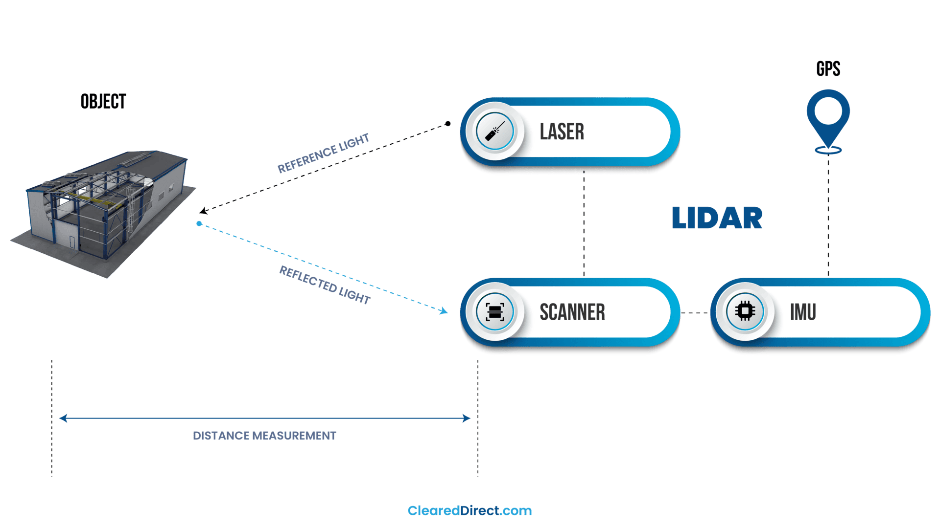
Together, these components let a UAV LiDAR drone convert simple laser reflections into millions of accurate data points, which are later transformed into 3D models.
Outputs: From Points to Maps
The first product of a flight is a point cloud. From it, teams derive:
- Digital Elevation Models (DEMs): These show the elevation of the earth’s surface in detail, including buildings, vegetation, and all visible features. DEMs are often used in urban planning and infrastructure projects where a complete picture of the surface is needed.
- Digital Terrain Models (DTMs): These go a step further by removing trees, buildings, and other objects to reveal the bare ground. DTMs are critical for flood modeling, road design, and any project where the underlying terrain must be clearly understood.
- 3D Contour Maps: From the point cloud, surveyors can also generate contour lines that connect points of equal elevation. These maps make slopes, drainage patterns, and changes in terrain easy to visualize, helping engineers and planners see how land will affect a project before work begins.
LiDAR vs Photogrammetry
Well, before diving into the details of LiDAR, it’s important to distinguish it from photogrammetry, since the two are often confused. Photogrammetry builds 3D models from overlapping photos and works well in open, well-lit areas.
LiDAR vs photogrammetry often comes down to conditions. LiDAR can capture bare earth under tree canopies and perform in low light or complex terrain, which is why many teams choose UAV LiDAR drones when precision under vegetation is required.

Why LiDAR UAVs Solve Modern Surveying Challenges
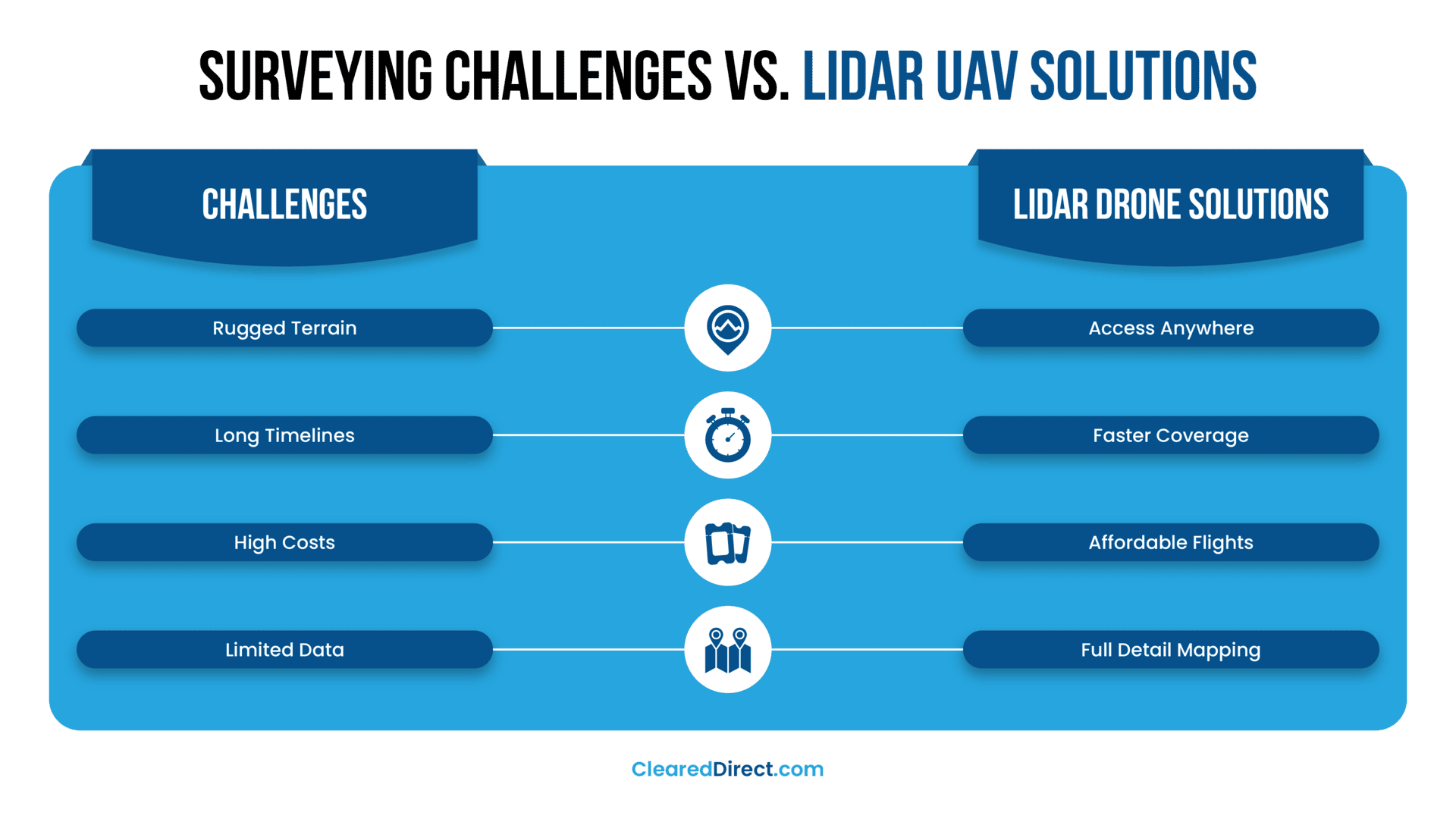
Traditional surveying methods often come with steep trade-offs: they are slow, expensive when aircraft are needed, and pose safety risks in rough terrain. Even when completed, results can vary widely depending on environmental conditions.
That’s where a UAV LiDAR drone makes a real difference. Equipped with a LiDAR sensor, it flies over the target area, gathers dense spatial data in a single sortie, and delivers precise 3D terrain models. What once could take weeks is now achievable in hours.
A study highlights this clearly: when mapping coastal terrain, UAV LiDAR consistently outperformed photogrammetry, offering better coverage, higher precision, and the ability to capture ground beneath vegetation where image-based methods failed.
The Real Benefits That Matter
The advantages of using LiDAR-equipped drones are clear in practice. Safety comes first: crews no longer need to enter steep slopes, unstable ground, or disaster areas just to take measurements. Speed is another gain, with entire landscapes mapped in hours instead of days or weeks. Projects also see greater cost efficiency, since there is no need to charter aircraft or keep large teams in the field.
Equally important is scalability. A UAV LiDAR drone can handle a small construction site with the same reliability it brings to thousands of acres of farmland or forest.
Finally, there is accuracy, the decisive factor that sets LiDAR apart. Unlike photogrammetry, LiDAR mapping can cut through vegetation and shadowed terrain to deliver consistent ground models in conditions where other methods fall short.
Applications of LiDAR Drone Technology
The strength of LiDAR is not in the technology alone but in how it adapts to different professional needs. From surveyors and planners to emergency responders and environmental scientists, each group relies on the same system for very different reasons.
Below, we look at how specific sectors apply LiDAR data to solve practical challenges.
GIS Professionals and Cartographers
For GIS specialists, precision data is the backbone of spatial analysis. A UAV LiDAR drone provides dense elevation measurements that support advanced cartographic work. The ability to generate Digital Elevation Models (DEMs), Digital Terrain Models (DTMs), and full 3D city reconstructions gives GIS teams reliable inputs for mapping projects.
What sets LiDAR apart is its capacity to enhance existing geospatial datasets. LiDAR mapping corrects gaps left by satellite or photogrammetry-based sources, particularly in areas with heavy vegetation or complex infrastructure. Analysts gain cleaner ground models, which improves slope analysis, watershed studies, and land-use planning.
Urban planners also benefit from these datasets. With UAV LiDAR technology, they can assess drainage, traffic networks, and flood zones more accurately, enabling smarter decisions about city growth and infrastructure upgrades.

Builders and Construction Managers
In construction, every project begins with a clear picture of the site. Traditional surveys often slow down this step, but a UAV LiDAR drone can scan the terrain quickly and deliver highly accurate base maps for pre-construction planning. This allows architects and engineers to design with confidence, knowing that the underlying site data reflects actual ground conditions.
Once work begins, LiDAR helps validate earthmoving and grading activities. Contractors can compare design specifications against as-built models, ensuring cut-and-fill operations are accurate and compliant. With this level of oversight, costly rework and delays are reduced.
The technology also supports the creation of digital twins—virtual replicas of construction sites that update as work progresses. By integrating LiDAR mapping into project monitoring, managers can track progress, measure volumes, and identify issues before they become expensive problems. In this way, UAV LiDAR technology brings measurable control to complex building projects.
Real Estate Developers and Land Brokers
For developers and land brokers, site selection and valuation depend on reliable ground data. A UAV LiDAR drone can provide accurate surveys that confirm land boundaries, reveal slope gradients, and highlight potential issues before deals move forward. This level of precision reduces legal disputes and supports fair property assessments.
Floodplain mapping is another critical application. By modeling drainage patterns and elevation changes, UAV LiDAR technology helps identify areas at risk of flooding. These insights inform investment decisions, guide compliance with zoning regulations, and prevent costly surprises during development.
LiDAR data also plays a role in visualization. Three-dimensional terrain models allow brokers and developers to present property potential in a way that static maps cannot. For investors, seeing a site’s elevation, contours, and planned structures in realistic detail builds confidence and strengthens negotiations.
Farmers and Agricultural Managers
Agriculture depends on understanding land as much as crops. A UAV LiDAR drone provides farmers with detailed soil and irrigation maps that show where water is pooling, draining too quickly, or failing to reach. This insight supports smarter planning for irrigation systems and better soil management practices.
LiDAR also enables canopy monitoring. By measuring crop height and density, LiDAR mapping can highlight variations across fields that may point to disease, nutrient stress, or uneven growth. Farmers can respond earlier, applying treatments or adjusting practices only where needed.
Erosion detection is another valuable use case. Small changes in terrain, often missed by visual inspection, become visible in LiDAR-generated elevation models. Tracking these patterns helps prevent yield loss and guides conservation strategies. Together, these applications turn LiDAR from a survey tool into an engine for precision agriculture.

Large Landowners and Timberland Investors
Managing extensive forested areas requires more than ground inspection. A UAV LiDAR drone can capture detailed measurements across thousands of acres, allowing landowners to build accurate forest inventories and estimate biomass with confidence. This data supports both operational planning and long-term valuation of timber resources.
Health monitoring is another area where LiDAR provides value. By detecting irregularities in canopy structure and growth patterns, UAV LiDAR technology helps identify areas affected by disease or pests. These insights allow managers to intervene earlier, reducing the risk of widespread loss.
For investors, LiDAR also plays a role in sustainability assessments. Reliable terrain and vegetation data make it easier to evaluate land productivity, monitor conservation practices, and document environmental compliance. This strengthens investment decisions while balancing economic goals with stewardship of natural assets.
Property Managers and Facility Owners
For large campuses and industrial sites, maintaining accurate maps is essential. A UAV LiDAR drone provides up-to-date layouts of buildings, parking areas, and surrounding land, giving facility teams a reliable base for daily operations. These datasets also make it easier to track utilities and underground infrastructure with greater precision than traditional surveying methods.
LiDAR also supports infrastructure inspections. By scanning rooftops, pipelines, and powerlines, UAV LiDAR technology helps managers detect issues before they escalate. Structural deformation, vegetation encroachment, or drainage problems become visible in the data, allowing teams to plan maintenance proactively instead of reacting to costly failures.
Expansion planning is another area where LiDAR proves valuable. Three-dimensional models of existing facilities ensure that renovations or new construction projects fit seamlessly within current layouts. This minimizes design errors and streamlines approvals while giving stakeholders a clear visual of proposed changes.
Public Safety and Emergency Services
Emergency planning depends on understanding risk before disaster strikes. A UAV LiDAR drone can capture terrain details that traditional surveys often miss, creating data-rich models for floodplains and landslide-prone areas. These insights give public safety teams the ability to predict where hazards are most likely to occur and prepare accordingly.
LiDAR is equally useful in evaluating infrastructure vulnerability. Bridges, levees, and roadways can be scanned to reveal subtle weaknesses that might fail under stress. When combined with other monitoring systems, UAV LiDAR technology becomes a critical tool for prioritizing repairs and reinforcing structures before an event.
Perhaps most important, LiDAR supports pre-disaster planning. By integrating LiDAR mapping into emergency response strategies, agencies can run realistic simulations, model evacuation routes, and identify safe zones with accuracy. This proactive approach saves both time and lives when crises unfold.
Search and Rescue Teams
When lives hang in the balance, every second counts. A UAV LiDAR drone can map challenging terrain in forests and mountains faster than traditional methods, giving rescue teams a clear view of where to begin their search. And because it flies above obstacles, even tree-covered slopes become navigable in data form.
Locating missing individuals becomes significantly faster when SAR teams add LiDAR-derived terrain maps to their toolkit. Although LiDAR alone doesn’t find people, the precise ground models help teams prioritize areas and plan safe access routes, speeding up the response.
In many operations, LiDAR is paired with thermal sensors to boost effectiveness. Thermal cameras detect body heat, while LiDAR provides structure and context—together, they give teams a clearer, faster, and safer way to locate individuals in distress. Studies show that combining these technologies improves outcomes in complex environments, especially where visual detection is hindered.
Wildlife Managers and Environmental Scientists
For conservation professionals, having accurate habitat data is essential. A UAV LiDAR drone can produce detailed maps of forests, wetlands, and grasslands, showing canopy height, density, and structure in ways that traditional surveys cannot match. These insights help researchers understand how wildlife populations use their environments and identify critical habitats that need protection.
LiDAR mapping also supports monitoring efforts. By detecting subtle terrain changes, managers can track erosion, measure deforestation, and assess the impacts of land-use change over time. Because LiDAR penetrates vegetation, it provides a clear view of both canopy health and the ground beneath, giving ecologists a complete picture of environmental change.
Regulatory compliance is another area where LiDAR proves valuable. Accurate, repeatable datasets allow agencies and non-profits to document conservation practices, demonstrate adherence to environmental standards, and support funding or policy decisions. With better data, organizations can balance development and conservation goals more effectively.
Challenges and Considerations
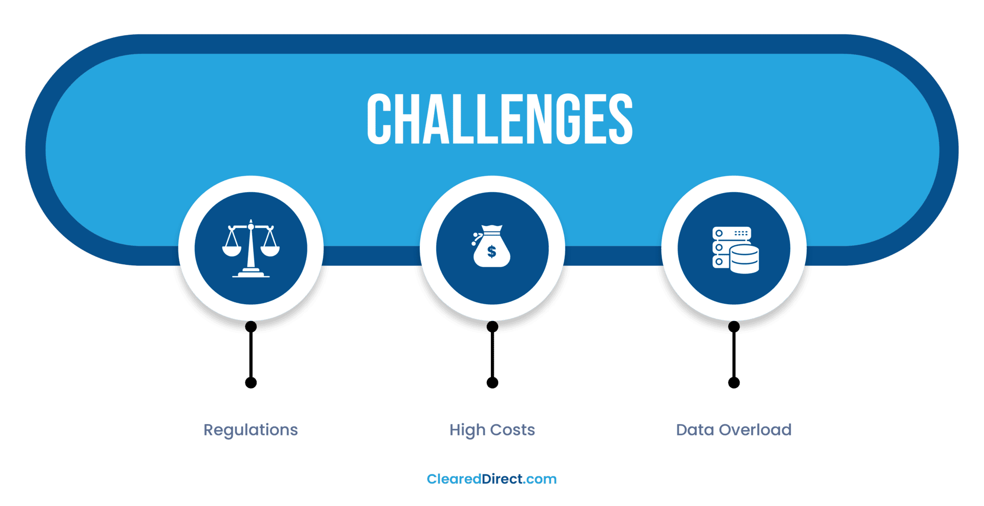
LiDAR has clear advantages, but adopting it isn’t as simple as buying a drone and flying into the field. Teams need to think about rules, costs, and how they will handle the large volumes of data that LiDAR produces.
Regulatory Hurdles
In many regions, commercial drone flights are tightly controlled. In the United States, for example, operators must comply with the FAA’s Part 107 rules for commercial UAVs. A UAV LiDAR drone cannot simply be launched over cities, highways, or restricted airspace without permission. Operators also need to be licensed, and some projects may require waivers or extra clearances. These steps are not impossible, but they do take planning and compliance know-how.
Cost of Hardware and Training
LiDAR sensors remain a high investment. When paired with advanced drones and software, the total cost can be a significant barrier. Add in the need for operator training and licensing, and the price grows further. For many smaller firms, the return on investment must be carefully evaluated before committing.
Data Management Challenges
Each survey generates millions of data points, producing massive point clouds that require proper storage and processing tools. This is where many teams feel the pinch: powerful computers and specialized software are often necessary to clean, manage, and analyze the data. Compared with LiDAR vs photogrammetry, the datasets are heavier and more complex to work with, but they also deliver far greater precision and reliability.
These hurdles don’t mean LiDAR should be avoided—they mean organizations need a clear plan. With budgets set aside for hardware, staff training, and proper data management, UAV LiDAR technology can deliver its full potential and become a reliable part of professional operations.
Conclusion
Across every industry we’ve explored, the advantages of a UAV LiDAR drone are clear. From building accurate GIS databases and supporting construction projects, to guiding farmers, land investors, and facility managers, the technology consistently delivers speed, safety, and precision. In public safety, search and rescue, and environmental science, it also plays a life-saving role by providing information that was once impossible to capture quickly.
What ties these applications together is versatility. The same system can serve urban planners, timberland investors, and conservation teams, each with their own goals and challenges. That adaptability is what makes LiDAR such a powerful addition to professional workflows.
Ultimately, UAV LiDAR technology is not just a way to collect data. It is a decision-making tool. By turning millions of measurements into clear models, it gives professionals the confidence to act.
If you’re considering LiDAR for your next project, you can reach out to us. ClearedDirect offers survey-grade UAV LiDAR mapping or other services and can guide you through the process from planning to delivery.
Frequently Asked Questions
LiDAR and radar serve different purposes. Radar uses radio waves and works well for detecting objects at long distances or in poor weather. LiDAR, on the other hand, uses laser pulses and delivers much higher-resolution data, which makes it better for creating detailed 3D maps. When precision is required, such as in surveying or mapping with a UAV LiDAR drone, LiDAR generally outperforms radar.
LiDAR is used to create accurate 3D models of terrain, vegetation, buildings, and infrastructure. Applications range from city planning and agriculture to forestry, disaster response, and environmental monitoring. A UAV LiDAR drone can capture this data quickly and safely, even in areas that are hard to reach on the ground.
No, humans cannot see LiDAR pulses. LiDAR systems typically use near-infrared or ultraviolet light, which falls outside the visible spectrum. The laser beams are invisible to the human eye, but specialized sensors capture and process the reflections.
Yes, some newer smartphones, such as high-end iPhones and iPads, are equipped with LiDAR sensors. These are smaller, consumer-grade versions that improve augmented reality applications, photography, and indoor mapping.
However, they are not as powerful as professional-grade LiDAR used in drones, surveying, or environmental monitoring.
No, LiDAR is not limited to drones. While UAVs are one of the most efficient platforms for wide-area mapping, LiDAR can also be mounted on airplanes, helicopters, ground vehicles, or even handheld systems. The choice depends on the project’s scale and goals, but UAV platforms remain the most cost-effective for mid-size areas.
References
https://www.jouav.com/blog/lidar-drone
https://www.flyability.com/blog/lidar-drone
https://www.faro.com/en/Resource-Library/Article/What-is-a-LiDAR-drone
https://www.yellowscan.com/knowledge/lidar-drone
https://oceanservice.noaa.gov/facts/lidar

Kevin Milewski
Kevin Milewski is the Chief Operating Officer at ClearedDirect, where he oversees operational strategy, technology implementation, and service delivery for aviation and commercial drone (UAV) projects. With a strong background in aviation services and facility management, Kevin focuses on improving safety, efficiency, and regulatory compliance across complex airport and industrial environments. At ClearedDirect, Kevin leads initiatives integrating drone surveillance, LiDAR imaging, and AI-driven facility inspection systems that help clients achieve higher safety and performance standards. His leadership contributes to the company’s commitment to precision, reliability, and data-driven decision-making in critical infrastructure operations. Kevin regularly contributes insights to ClearedDirect’s knowledge hub, covering UAV surveillance, aviation operations, and facility optimization topics. His work reflects practical industry experience and a dedication to advancing innovation in aviation and technology management. Connect with Kevin on LinkedIn to learn more about his work.
RECENT POSTS


Recent Comments
CATEGORIES
- Aviation Facility Management
- Commercial Cleaning
- Construction
- Digital Mapping & Analytics
- Drone & LiDAR Inspections
- Drone And LiDAR Guides
- Facility Cleaning Resources
- Facility Management Guides
- Facility Management Risk
- Facility Management Technology
- Facility Operations
- Facility Security Management
- Identifying & Eliminating Inefficiencies
- Operations Management Guides
- Process Optimization
- Security Management Guides
- Staffing Augmentation Guides
- Surveillance UAV Drone Guides
- UAV Drone Mapping
- Uncategorized
TAGS
2025 facility trends aerial surveillance aircraft cleaning airline operations airport compliance management airport operational risk management airport personnel airport terminal operations Aviation Operations Aviation Risk Management aviation security risk assessment aviation services AviationStaffing aviation staffing Commercial Cleaning Services Commercial Drone Surveillance Commercial Facility Security Drone Surveying Emergency Response Planning Facility Hygiene Compliance facility maintenance facility management Facility Risk Assessment Facility risk management facility services Green Cleaning for Facilities ground handling services integrated facility management services Operational Efficiency Strategies operations management outsource facility management outsourcing airline services outsourcing airport services passenger experience enhancement Physical Security Best Practices proactive maintenance Scaling janitorial operations seasonal peaks staff augmentation Staffing Augmentation Staffing Challenges Aviation terminal facility security TSA FAA risk mitigation uav infrastructure inspection uav lidar technology
Leave a Comment